

William Dargue A History of BIRMINGHAM Places & Placenames from A to Y
Gannow Green
B45 - Grid reference SO985780
Gannou: first record 1330
In the late 1960s Birmingham faced a major task of slum clearance and so began to build on green sites beyond the city boundary. The housing estate of Frankley in Worcestershire is one of these developments.
Gannow Green lies at the west end of Frankley. The green itself, an agricultural feature, probably dates from the Middle Ages when the term usually referred to common land over which local people
had certain rights. Chief of these was that of grazing their livestock. Gannow may derive from two Old English words: gamen and ho: the first element meaning 'to game' or 'to
play'; the second a topographical word meaning 'a ridge (of land) that sticks out'. The implication is of a 'recreation area on a hill'. What the origin of this may have been remains open to
conjecture, although it suggests a site perhaps performing the function of a village green.
Little is known of the early history of the manor of Gannow. It is first found in the records in 1330 when Hugh de Mortimer obtained a grant of free warren here. This was in effect a licence
bought by a manorial lord from the Crown to hunt on his own land small game, such as badger, fox, hare, otter, rabbit, squirrel, partridge and pheasant. This rather suggests a resident or at
least a semi-resident lord. In 1407 the manor of Gannow was held by Richard and Elizabeth Ruyhale from the Earl of Warwick and then passed through various families including the Boleyns. Thomas,
Earl of Ormond c1477-1539, the father of Anne Boleyn was lord of the manor. In the 19th century Gannow manor passed with that of Cofton Hackett to the Earl of Plymouth.
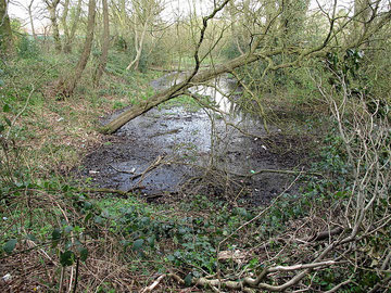
Take a look at Gannow Green moat.
In 1961, ahead of building development, Gannow Green Moat was excavated by Birmingham Archaeological Society's junior fieldwork group directed by B K Roberts. It was found that the site had been occupied from the 13th century to the 15th century. On the south side was found a massive stone curtain-wall which had been built in the first half of the 14th century, and a fine tiled hearth of cI400. Evidence was also uncovered of buildings with tiled roofs.
This wooded moated site at the west end of Devon Road, now a Scheduled Ancient Monument, is the location of the medieval manor house. Now dry and grassed, the moat was dug to surround a
timber-framed building of some size and prestige. This moat was edged with a sandstone wall and must have been an expensive venture, more a display of status than for defence, and only undertaken
by people of some wealth.
Two fishponds east of the moat, around Devon Road/ Kent Road, and around Lismore Close must have provided an important addition to the medieval diet; these too were a status symbol. Although the
sites are now covered by housing, part of the dam of one of the ponds can still be seen alongside Mull Close. The dam was originally built across the River Rea, though that river has subsequently
diverted to its present course.
Gannow windmill is no longer there but it features on the 1st Edition Ordnance Survey map of 1834. Situated on a site north of New Inns Lane in the Ormond Road area, it may have
had a relationship with Frogmill on the River Rea nearby. From the 18th century and earlier, when watermills were turned over to metal industries, a windmill was often built to continue grinding
the corn.
William Dargue 02.08.2010/ 16.10.2012
For 19th-century Ordnance Survey maps of Birmingham go to British History Online.
Map below reproduced from Andrew Rowbottom’s website of Old Ordnance Survey maps Popular Edition, Birmingham 1921. Click the map to link to that website.
