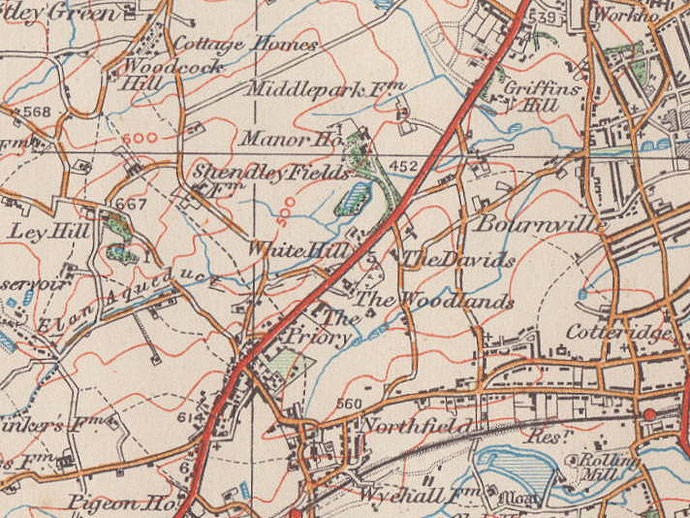
Shenley
Shenley Fields, Shenley Green/ Lower Shenley, Shenley Hill
B29/ B31 - Grid reference SP016811
Also known formerly as Shendley, the name is from the Old English scen leah probably meaning 'beautiful or bright clearing'. There are other similar placenames across England. Here was one of Northfield's open strip fields which lay north of Merritts Brook in the area around Shenley Lane, Shenley Fields Road and Shenley Hill. After the open field had been enclosed in the 18th century into a large number of regular four-sided fields, the land came into the ownership of three farms. The most northerly, Shenley Court Farm is now the site of the secondary school of the same name; Shenley Hill Farm was on the road of the same name where Fourlands Road now runs; and at Shenley Green/ Lower Shenley stood Shenley Fields Farm (or Lower Shenley Farm) where St Davids' Church now stands.
Shenley Fields Mill was a windmill which stood on Shenley Lane. Recorded in Upper Shenley Fields on a map of 1692, it was probably a corn mill of medieval origin. The mill does
not appear on the Northfield Tithe Map of 1839.
At the end of World War II only a few hundred people lived in this rural area. The district was built up after World War 2 as part of municipal developments extending outwards from Weoley Castle;
by 1958 there were some 8000 new residents. A substantial part of the land here was owned by the Bournville Village Trust who, in conjunction with the City Council, undertook its largest single
housing development to date. Some 600 houses for rent were built here in a mix of styles, the majority completed by c1955, the remainder by the early 1970s. A major scheme is currently underway
to refurbish the houses, the community facilitites and the green spaces of the district. The whole area now has a population of about 15,000.

Kings Norton Union Cottage Homes - Shenley Fields
In the triangle between Woodcock Lane and Shenley Lane the King's Norton Poor Law Union built a series of cottage homes to accommodate and provide vocational training for pauper children away from the adults’ workhouse on Kings Norton Green. (The Birmingham Union built cottage homes at Marston Green, the Aston Union homes were at Erdington.)
In 1887 four cottage homes were opened with 20 children in each. There was a school on site and workshops to train children in tailoring and shoemaking. Girls were trained to go into service and boys also learnt gardening. In 1890 two more homes were built, the school extended and an infirmary added. Three years later two more homes were opened and in 1899 a swimming baths was built. Two further homes opened in 1905.
In 1912 King's Norton Union became part of the Birmingham Union became known as Shenley Fields Cottage Homes. An Assembly Hall was built in 1923; initially used for church services, it was later used for social events when children attended local church services instead. Another home was built in 1935. From the 1940s older children attended local schools while the Cottage Homes nursery school was opened up to local children.
In 1982 Birmingham Social Services began to close the homes one by one over the next five years, the last closing in 1987. All the buildings were subsequently demolished and private housing built on the site.

St David's Church
The new district was split between the parishes of St Laurence, Northfield and St Gabriel, Weoley Castle and so it was decided to build a new church and create a parish of Shenley.
Bournville Village Trust donated a site, formerly Lower Shenley Farm's orchard, and a church hall was built to double as a church. It was dedicated by Bishop Wilson in 1962. The first sod on the new church site was cut on St David's Day 1969, and pieces of stone from St David's Cathedral in Wales were presented which had been brought in a handcart pushed by local scouts.
The church building was consecrated the following year. It is designed with all 300 seats facing the sanctuary and with the priest at the altar facing the congregation for the celebration of the
Eucharist. The central area is a flexible space and there are meeting rooms off. Although this is a modern church whose design accommodates congregational participation and multi-purpose use,
regard has been paid to the historic and symbolic aspects of the Christian tradition.
Above the entrance to the church a 2-cwt bell by Taylor's of Loughborough hangs in a small bell-tower. At the foot of the tower a stone from St David's Cathedral has been set into the floor.
Angels are shown on the outside of the main doors, with the birth and death of Christ represented on the screen. Plaques on the doors represent the four Evangelists and the Resurrection of
Christ. In the baptistery is a concrete font whose wooden cover is adorned with a bird symbolising both the legendary pigeon of St David, and the dove, a symbol of the Holy Spirit. Various items,
including the candlesticks, communion plate, and processional cross were designed by Edwin Mason and made by teachers at nearby Shenley Court School.
William Dargue 10.03.2009/ 23.09.2012
For 19th-century Ordnance Survey maps of Birmingham go to British History Online.
Map below reproduced from Andrew Rowbottom’s website of Old Ordnance Survey maps Popular Edition, Birmingham 1921. Click the map to link to that website.