William Dargue A History of BIRMINGHAM Places & Placenames from A to Y
Quinton/ The Quinton
B32 - Grid reference SO991848
The Quyntain: first record 1774

The parish, known as Ridgacre/ Ridgeacre until 1901 was, with Halesowen parish, a detached part of Shropshire until 1844 when it came under the administration of Worcestershire.
Until Henry VIII's dissolution of the monasteries, most of Quinton had been owned by the wealthy Abbey of Halesown. By the end of the 19th century Quinton had developed as a small compact village around the tollgate on the Hagley Road at its junction with Spies Lane. Quinton was then the area around the church, with Ridgacre lying to the west bordering Harborne. Quinton became a separate civil parish in 1894.
In 1909 as celebrations were held in Quinton Park to mark the district's amalgamation with Birmingham, Parliament passed the Housing & Town Planning Act to give local
councils wide-reaching powers to plan future housing development. Chaired by Neville Chamberlain, Birmingham's Town Planning Committee immediately took the opportunity to plan housing, highways,
transport, amenities and services for Quinton.

Birmingham City Council's scheme for low-density housing became the first in the country under the Act and was held up as a model for other local authorities.
Between the First and Second World Wars Quinton was almost completely built up, its population increasing by twenty times from 1921 to 1961. In the last quarter of the 20th century the area was
dramatically changed by road developments, the Quinton Expressway and the M5 brutally cutting through the centre of the old village in 1970. Nonetheless, the shopping centre around Hagley Road/
College Road remains a focus of the district.
Most of Quinton lies on sand and pebble land. Formerly this would have been heathland and covered with long tough grass, low bushes and few small trees. The soil is generally light, drains very
quickly but is not particularly good for farming.
Where there were more pebbles early farmers would find difficulty ploughing, but sandy soils would be much easier to tackle. Sand and pebble lands lie west of the City Centre from Great Barr, though Aston and Hockley, Smethwick and Harborne, to Quinton and Rubery. Because this is quick-draining soil it provided easy passage for travellers whatever the weather. As early as the New Stone Age long-distance routes across Britain had developed and were used for trade. One such ancient track is believed to have crossed the sand and pebble lands via Quinton, Barr Beacon and Cannock linking Cardigan Bay in South Wales with the North of England.
However, the archaeological record reveals nothing until Roman times. The keen eyes of Birmingham's gardeners have often been responsible for many finds in the city, particularly coins. In
Blandford Road a rare British find of an Alexandrian billon tetradrachma of the Emperor Diocletian (284-305) was made by a householder while digging in his back garden.
Cwen's tun means 'queen's farm' in Anglo-Saxon. However, no queen is known to be associated with the area, and the name probably just means 'woman's farm'. An alternative explanation is
that the placename derives from quintain jousting. Dating from the Middle Ages, this was a sport designed to train mounted knights for battle. The knight tilted at a target on a crossbeam on a
revolving stand at the other end of which was a sandbag. If he was too slow, the horseman might be hit as the sandbag swung round. The sport was practised in various forms until the 19th century.
It is thought the quintain may be the precursor of the Victorian merry-go-round. Unusually this placename was generally preceded by the definite article and known as The Quinton, although this
has largely dropped out of use during the 20th century.
The old village centre is off Hagley Road West on Quinton High Street between the Quinton Expressway and the M5 motorway. However, what was later known as Quinton manor was
called Ridgacre at Domesday. This too is an Anglo-Saxon name, hrycg aecer meaning 'ridge acre' or perhaps just 'ridge field'. This name was still used in the 19th century but is no
longer. The modern district of Quinton which amalgamated with Birmingham in 1909, lies between Hagley Road West and Quinton Road West.
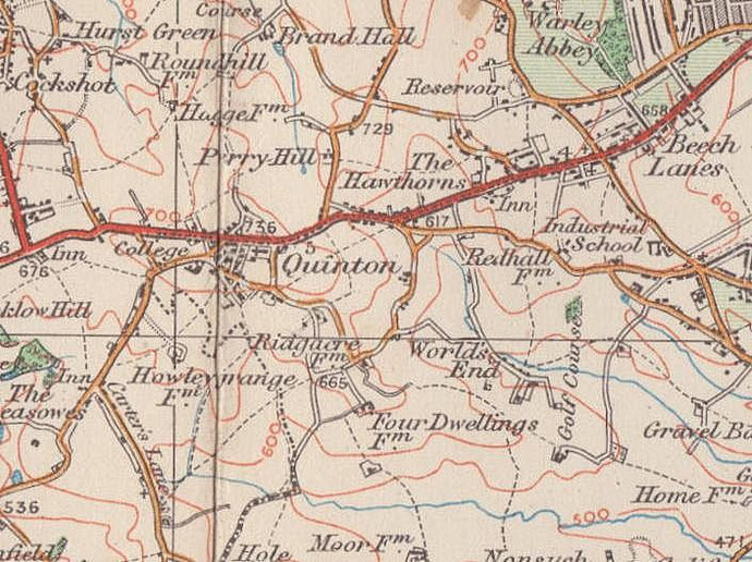
Map below from National Library of Scotland shows the Ordnance Survey 6 inch map revised 1902 with a modern map alongside. Click the map to go to that website.

Take a look at Quinton Nailers Cottage on Ridgacre Road West at the High street. Built in the 18th century, this former nailmakers’ house is certainly the oldest building in Quinton and is Grade II Listed. Many low-paid agricultural workers in the south of the Birmingham area made nails as a secondary occupation. Although very poorly paid, it was a work that could be undertaken by all the family at home by all the family after work or when farmwork was slack.

‘The Old Nail House of Quinton’ is a two-bay, two-storey brick house parallel to Ridgacre Road. There is a single-storey brick extension to the west on the corner of the High Street. Now used as an entrance hall this was the nailers’ workshop.
The main part of the house was thought to be 18th-century. However, in 2007 the new owners had the external rendering removed from the walls of the main block which revealed lower walls built of stone and likely to date to the 16th century while the brickwork above is probably 17th-century. Inside the house there is wood wall panelling which is believed to have come from Witley Court, Worcestershire, a country house that was destroyed by fire before World War 2. Some of the panelling dates from the 17th century, some is 19th-century. The whole house has now been restored to reveal its original features.
A mid-20th-century extension to the rear of the cottage had three 18th-century windows windows with intersecting Y-tracery in iron probably cast in Coalbrookdale, and original glass from the old Quinton tollhouse which was demolished in 1946. This was unstable and demolished c2007. A new extension was built using traditional materials and techniques and the windows reinstated.

Images before and after restoration of the Nailers Cottage courtesy of Pete Ward of Heritage House Builders, specialists in the Conservation and Restoration of old buildings.
See Acknowledgements to link to their website with an illustrated description of the work they did on this cottage and for information about their other projects restoring old houses using traditional methods.
In 1753 Halesowen/ Stourbridge Turnpike was set up. The earliest route from Birmingham followed the old Bromsgrove Turnpike to Edgbaston via Holloway Head and Wheeleys Lane. At Edgbaston church the Old Bromsgrove Road turned south past the hall, while the Halesowen Road continued by way of Edgbaston Park Road via Harborne High Street, War Lane and Ridgacre Road to join the Hagley Road at The Quinton. A more direct route from Broad Street was later made following the modern Hagley Road.

William Hutton commented wrily in 1781:
[The road] to Hales-Owen, eight miles, like the life of man, is chequered with good and evil; chiefly the latter.
Chequered or not, the company were nonetheless empowered to collect their dues at the tollgates with their adjacent keeper's cottages at Edgbaston Five Ways, at the Two-Mile Stump at Sandon Road near Bearwood and at the Quinton.
The octagonal Quinton tollhouse at College Road which was built c1877 survived until 1946.

Quinton Farm stood near the junction of Hagley Road West, Monckton Road and Kingsway. Also known as Tinkers Farm or Monckton Farm, this was a Georgian two-storey brick building with five bays rebuilt around an older farmhouse in 1750. The Kings Highway public house now stands on the site.
Farmer Ambrose Foley who had become a Methodist, invited John Wesley to stay here in 1778. At first the barn was used as the Methodist meeting house, but as attendance increased Foley paid for a preaching house to be built on the Hagley Road West to the rear of the tollhouse. Known as Ambrose Foley's Preaching House this Methodist chapel survived until 1877 when the new Hagley Road Wesleyan Chapel on Ridgacre Road was built to replace it.
This chapel closed in 1935 when the Wesleyans merged with the Primitive Methodists; the building was subsequently used by the General Post Office as Quinton sorting office until 1948. At Hagley Road West and College Road next to the toll house, Quinton Wesleyan Chapel survived until 1935 when Wesleyans and Primitive Methodists united in the Primitive Methodist Chapel built on College Road by Darlaston preacher William Stringer in 1888. This was demolished for the construction of the M5 motorway in 1967 and the present Methodist church built nearby opened the following year.

Near the junction of College Road and Spies Lane stood Bourne College. Named after its founder, Hugh Bourne, this was a large boarding
school built in 1882 in gothic-style with a prominent central tower on a 10ha site much of it now replaced by the M5 motorway. It catered for 1200 boys from Primitive Methodist families, but
numbers fell as state secondary provision improved and in 1918 the college was opened up to other Christian denominations.
The school closed in 1928 and Birmingham Corporation altered the buildings which were reopened as Quinton Hall, residential accommodation for elderly men. Demolished in 1978 for housing development, the headmaster of Bourne College, T J Stewart Hooson is commemorated by a streetname on the estate.
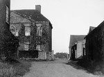
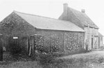
Click to enlarge the images below which are 'All Rights Reserved' and courtesy of Bernard Taylor of the Quinton Local History Society from the John Hope Collection, with the exception of the right-hand image which is a postcard of unknown origin. See Acknowledgements to link to the Quinton websites.
Left to right: Quinton Farm, Quinton Farm barn, the Wesleyan chapel in the background with the toll house in front, College Road Methodist Chapel, Bourne College.


Take a look at Christ Church.
The strength of Methodism in the area may be related to the fact that Quinton was part of the parish of Halesowen and the parish church was some miles away. Local people were remote from their
parish church both physically and culturally. Indeed it was not until 1840 that Quinton's parish church, Christ Church was built on Hagley Road West on land given by Lord Cobham. A parish was
created out of that of Halesowen the following year.
This red sandstone church is designed in early English gothic style and has a central aisle and chancel. It has a small single-bell turret with a pointed spire. In 1890 the church was restored by
Osborn & Reading and a west entrance added in 1928. There is good Victorian stained glass in the east windows which dates from 1862.
Burials took place in the churchyard until 1927 after which the ground was made into a park area. The original buildings of Quinton National (ie. Church of England) School which had been built in 1842 next to the church with accommodation for a hundred children, were demolished in 1971.

St Boniface Church
At the east end of Quinton on Quinton Road West St Boniface Church is a brick church typical of its time. Consecrated in 1959, it has a steeply pitched roof and clerestory and was designed by the partnership of Bromilow, While & Smeaton. Its gabled west front is surmounted by an octagonal bell turret with a copper roof. The altar by the nationally renowned architect W H Bidlake was brought here from R C Carpenter's demolished church of St Stephen which stood on Newtown Row from 1844 to 1950.
Quinton Cemetery on Hagley Road West was opened in 1923 by Birmingham Corporation just beyond the city boundary on a site of c20ha since
extended. The chapel designed by J A Swan has been demolished.
William Dargue 04.04.2009/ 28.12.2020
For 19th-century Ordnance Survey maps of Birmingham go to British History Online.
Map below reproduced from Andrew Rowbottom’s website of Old Ordnance Survey maps Popular Edition, Birmingham 1921. Click the map to link to that website.