

William Dargue A History of BIRMINGHAM Places & Placenames from A to Y
Olton, Ulverley, Ulverley Green
B92 - Grid reference SP146825
Oltun: first record 12th century
Beyond the Birmingham boundary in Solihull, Olton was formerly known as Ulverley, 'Wulfhere's clearing' until a new market town was created at Solihull c1200.
Thereafter the orginal settlement became known as Oltun from Old English eald tun, 'the old farm' or 'the old village'. At the west end of Castle Lane just off the Warwick Road the manor house of Ulverley stood until a larger house was built at Hobs Moat.
Well worth a visit - Hobs Moat
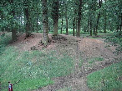
This is a large, clearly defined double-moated site. A Scheduled Ancient Monument, it is the site of Ulverley's fortified manor house built by William de Odingsells in the 12th century. Also known as Odensels/ Odinsells Moat or Odingsell Hall, the moat is now dry and the site overgrown by mature trees.
This significant medieval site with high banks and deep ditches takes its name from the medieval word hob which meant a hobgoblin or mischievous sprite. It was often applied to apparently artificial but unexplained landscape features which were therefore thought to have been made supernaturally.
The site impressed Birmingham's first historian, William Hutton in 1783:
HOGG'S-MOAT.
At Oltenend (Old Town) originally Odingsell's-moat, now Hobb's-moat, the ancient manor-house of Solihull, after it had changed its lords at the conquest. William the First granted the manor to a
favourite lady, named Cristina; Ralph de Limesie married her, who became lord of the place, but despising Ulverley, erected this castle. The line of Limesie continued proprietors four descents;
when, in the reign of King John, it became the property of Hugh de Odingsells, by marrying a co-heiress. The last of the Odingsells, in 1294, left four daughters, one of whom, with the lordship,
fell into the hands of John de Clinton; but it is probable the castle was not inhabited after the above date, therefore would quickly fall to decay.
The moat is upon a much larger plan than Ulverley, takes in a compass of five acres, had two trenches; the outer is nearly obliterated, but the inner is marked with the strongest lines we meet
with. This trench is about twenty feet deep, and about thirty yards from the crown of one bank to the other. When Dugdale [in the 1630s] saw it, about a hundred and fifty years ago, the
center, which is about two acres, where the castle stood, was covered with old oaks; round this center are now some thousands, the oldest of which is not more than a century; so that the timber
is changed since the days of Dugdale, but not the appearance of the land.
The center is bare of timber, and exhibits the marks of the plough. The late Benjamin Palmer, Esq; a few years ago, planted it with trees, which are in that dwindling state, that they are not likely to grow so tall as their master. It lies in a pleasant situation, upon a descent, so that the trench in one part is dry, and in another three or four yards deep in water. A place of such desolation, one would think, was a place of silence--just the reverse. When I saw it, Feb. 23, 1783, the trees were tall, the winds high, and the roar tremendous.
William Hutton 1783 An History of Birmingham Edited
The hamlet of Ulverley was at the junction of Ulleries Road and Lyndon Road; Ulverley Green, probably a patch of common open grazing, was at Ulverley Green Road.
The modern district of Olton was built up from late Victorian times and is now focussed on the Warwick Road around Olton railway station at Ulverley Green Road.
William Dargue 20.09.2008/ 31.07.2010
For 19th-century Ordnance Survey maps of Birmingham go to British History Online.
Map below reproduced from Andrew Rowbottom’s website of Old Ordnance Survey maps Popular Edition, Birmingham 1921. Click the map to link to that website.
