William Dargue A History of BIRMINGHAM Places & Placenames from A to Y
Doe Bank
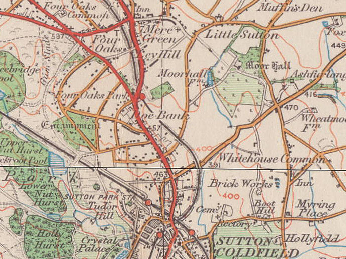
B74 - Grid reference SP121972
Dove Bank: first record 1774; Doe Bank 1821
South of the junction of the Lichfield Road and Four Oaks Road is a location known as Doe Bank, which is not an uncommon name. There was a small hamlet around the junction by 1834. The name is no longer in use.
The name is first recorded as Dove Bank in 1774 in a lease 'from Mary Dallaway of Birmingham, spinster, to William Devon of London, gent., of a messuage [house], lands and appurtenances at Dove Bank in the parish of Sutton Coldfield co. War., lands at Dove Bank adjoining Sutton Park.'
The word doe is used of a female deer, usually fallow or roe deer. However, it is also used of other kinds of deer and of other species, particularly rabbits.
If the placename refers to 'doves', that term was used in the past for any member of the pigeon family. These birds, like many other wild birds, were trapped by laying nets with bait in and were an important meat supplement to the peasant diet.
Perhaps the name Doe Bank is the more plausible, as the location was formerly adjacent to Sutton Park, which had been a deer park since Tudor times. There may have been artificial bank here marking the boundary of the park or a compartment within it.
See also Four Oaks.
William Dargue 09.11.2008/ 01.08.2010
For 19th-century Ordnance Survey maps of Birmingham go to British History Online.
Map below reproduced from Andrew Rowbottom’s website of Old Ordnance Survey maps Popular Edition, Birmingham 1921. Click the map to link to that website.