

William Dargue A History of BIRMINGHAM Places & Placenames from A to Y
Northfield
formerly in Worcestershire - one of the Domesday manors of Birmingham
B31 - Grid reference SP022796
Nordfeld: first record in the Domesday Book 1086
Northfield is one of the ancient parishes of Birmingham. In 1868 N E S A Hamilton's The National Gazetteer of Great Britain and Ireland described the parish:
Northfield, a parish in the upper division of the hundred of Halfshire, county Worcester, 6 miles South-West. of Birmingham, its post town, and 2 West of the King's Norton station on the
Gloucester railway. It is situated on the small river Rea, and on the road from Birmingham to Worcester.
The parish contains the hamlets of Selly, Hay, Shendley, and Bartley. A portion of the inhabitants are employed in nail making. There are chemical works and freestone quarries. The surface is flat towards the East, but hilly in the West. The soil is a fertile loam, producing good crops of wheat and beans.
Edited
The population expansion of the 12th and 13th centuries saw the building of a number of substantial farms within moats.
Old Moat Drive by Northfield church is named after a moat 60m square at Moat Farm. It was levelled in 1930 and houses were built on the site in 1965. This may have been the site of Northfield manor house from the 11th century until the 14th century when it was superseded by Weoley Castle.
There was a moat at The Grange on Hanging Lane and Tinkers Farm, its site now occupied by a school. Staple Hall Farm on Aldersmead Road was a moated site and Middleton Hall may also have been surrounded by a moat.
During the Middle Ages the manor was equally referred to as Northfield or as Weoley; the two names seem to have been synonymous. The manor was divided into three tithings: Northfield itself, Selly which already existed at Domesday, and Middleton which was created towards the end of the 14th century.
By the Middle Ages open fields had been organised in the manor. Shenley Fields lay north of Merritts Brook at Shenley Lane. On Victoria Common between Church
Road and St Laurence Road evidence of ridge and furrow can be seen and on the recreation ground by the River Rea near Staplehall Road two examples of ridge and furrow are still visible.
There were still open fields in Northfield in the 18th century but all had been enclosed before the final enclosures elsewhere.
(See open fields in the Glossary.)
Although the name is of Saxon origin, Northfield's lighter soil, which overlies bunter pebble beds, must have been farmed for hundreds of years before the Germanic settlers came.
Stone Age
Certainly people of the Stone Age passed this way - a neolithic scraper of yellow chert was found in Quarry Lane, and on Tessal Lane a stone axe was discovered also dating from the New Stone Age. Whether their owners lived nearby or these were tools lost by passers-by can never be known.
Bronze Age
No evidence of a Bronze Age dwelling has been found in Birmingham, but the evidence of heat-shattered pebbles forming large burnt mounds alongside Northfield's streams shows occupation of the area over a long period of time.
One mound near Merritts Brook Lane measures 16 metres in diameter. Two others, one near Woodlands Park Road and another at the foot of Bell Hill have been radiocarbon-dated to c1070 BC and c1120 BC respectively. The evidence is not conclusive, but the hot stones are believed to have provided heating for Bronze Age saunas.
The Roman period
In the Roman period the road from the Bristol Channel port of Sea Mills to the north-east of England passed through Northfield. Its Roman name is unknown, but it became known as the Upper Saltway during the Middle Ages because it was one of the routes used to bring salt extracted from the Droitwich brine springs. The road may well have performed the same function throughout and probably before Roman times.
Archaeologists have found traces of the road where it crosses over the Lickey Hills. It is thought then to have run parallel to the Bristol Road South through Rednal and Longbridge and on to Metchley fort near Birmingham University. In 1963 archaeologists, alerted by building workers, made excavations at the corner of Swarthmore Road and Bryony Road and discovered at least five periods of Roman road construction. The fact that the road had been repaired and rebuilt a number of times demonstrates that this must have been a highway of more than local importance.
More Roman evidence was discovered by chance off the Bristol Road South on Pigeon House Hill near Hill Top Road where the Northfield hoard was found to have been buried. The trove included coins
of Claudius II Gothicus (268-270 AD), Diocletian (284-305), Maximian (285-286), Constantius (305-306), Constantine (306-337) and surely belonged to a person of some means who lived close by. Who
can tell what caused a family to bury their money and never return to claim it.
Anglo-Saxons
The name, Northfield derives from Anglo-Saxon, nord feld and is a name common across the country. It is likely that this settlement was named in the same way as neighbouring Kings Norton being north of Bromsgrove and at the limit of Saxon penetration from the south. The early West Saxon kingdom of the Hwicce covered all of Worcestershire and beyond. Its northern limits are represented in Birmingham by the ancient parishes of Kings Norton, Northfield and Yardley. It is reasonably conjectured that this Hwiccan kingdom was the pre-Roman tribal area of the Celtic Dobunii. In 628 the Saxon Hwiccans were conquered by the Anglian, King Penda of Mercia, although the kingdom continued to be administered as a separate unit. Archaeological evidence, or rather lack of it, suggests sparse Saxon settlement and it is likely that the kingdom had a predominantly Celtic population.
The second element of the placename, feld, did not originally mean 'field' in the modern sense ie. an enclosed agricultural unit of land. Feld referred to open land as opposed
to forest. The land here is light soil over bunter pebble beds and would have been much less densely wooded than the clay lands of the Forest of Arden to the east. It may well have already been
cleared for cultivation before the Saxon settlers arrived.
The Norman Conquest
Before the Norman Conquest Anglo-Saxon Northfield was a manor of some substance. Worth £8 for tax purposes during King Edward's reign, it was the most prosperous of Birmingham's manors. But in the twenty years after the Conquest its value had plummeted to less than a quarter of its pre-Conquest worth and a number of other manors were now of greater value.
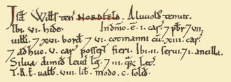
Nonetheless, the manor could boast its own priest (Aston had the only other), and it still had twice the number of ploughteams as Birmingham and the potential of five more. The compilers of the Domesday Book wrote:
William [FitzAnsculf] holds Northfield. Alfwold held it. 6 hides . . .
In the demesne 1 ploughteam. A priest & 7 villeins & 16 bordars & 6 cottars with 13 ploughteams, 5 more ploughteams would be possible. 2 slaves & 1 female slave.
Woodland half a league long & 3 furlongs wide.
In the time of King Edward it was worth 8 pounds, now 30 shillings.

Well worth a visit - Northfield village.
The heart of Northfield is protected by law as the Northfield Old Village Conservation Area and comprises Church Hill, Church Road, Norton Close and Rectory Road. The significance of the
surviving village centres of Harborne, Kings Norton, Northfield and Yardley was recognised when they were designated in the City's second batch of conservation areas in 1969. They had been
incidentally preserved in the 18th century when the old roads were realigned as turnpikes to bypass the narrow congested lanes of the old village centres.
St Laurence church
The conservation area is focussed on the Grade I Listed church of St Laurence which dates back at least to Domesday when a priest is mentioned; there may well have been an Anglo-Saxon church
here.
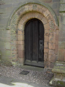
A rare Birmingham survival is reset into the new north wall of 1900. This is a round-arched Norman doorway of c1170 bearing a zig-zag pattern typical of its date. Also surviving from the 12th-century are two plain windows with carved animal heads set in the north and south faces of the tower. The chancel survives completely in its early English style of the 13th century. In the late 13th century the tower was built, although only the lower part now survives, the upper having been rebuilt to its present height in the 15th-century. Also at that time the chancel and nave roofs were raised and the south porch replaced by the present half-timbered one which stands on a sandstone base.
The present pulpit was made of wood from the medieval rood screen which would have been removed around the time of the English Civil War. Hannoverian arms hang over the tower arch; but all other
18th-century internal arrangements such as high pews and low ceilings were removed in a sensitive restoration in the late 19th century when the chancel floor was raised and the fine rood screen
installed. The north aisle was built in 1900 by G F Bodley in an accurate 14th-century style in keeping with the rest of this historic building, which still looks much as it did in the Middle
Ages.
In 1730 a ring of six bells was cast and installed by Joseph Smith of Edgbaston. The tower was renovated in 1999 when a new ground floor ringing chamber was created. A new steel bell frame was
placed below the 1637 frame which has been retained for historical interest. The bells were re-hung with the addition of two new trebles making a peal of ten.
Northfield burial registers date from 1560, but burials must have taken place in the churchyard from Norman times and probably earlier. To accommodate an increasing population, the churchyard was extended in 1881 and in 1899. It is now closed to all but existing family plots.
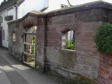
Take a look at Northfield Pound and The Great Stone Inn.
Standing opposite Northfield church is the Great Stone Inn. Although of Georgian appearance, this is a timber-framed hall of the late medieval period. Altered in the 17th century and facaded in brick a hundred years later, it was further extended in the 19th century and modified internally by the brewery in the 1970s.
Adjacent is a fine example of 17th-century village pound fronted by a 2m-high sandstone wall. Stray farm animals would be kept here to be reclaimed on payment of a fine to the bailiff of the
manor. Inside the pound is a large boulder after which the pub is named. This glacial erratic from north Wales stood for ten thousand years after the last Ice Age at the corner of Church Hill and
Church Road until it was moved here in the 1950s.
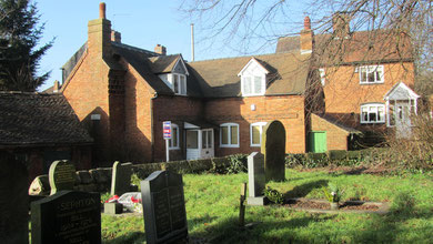
The Rectory on Rectory Road is modern. However the outhouses, which are now converted into garages, are a 16th-century timber-framed building with an 18th-century brick wing.
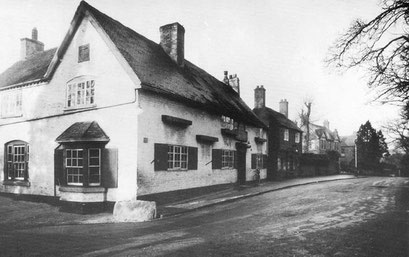
On Church Hill, at the other end of the social scale, are former nailmakers' cottages including one with chimneystack unusually incorporating a pigeoncote and a surviving outbuilding which was the nailmaking workshop. Nailmaking was a secondary occupation for many low-paid agricultural workers especially in the south of Birmingham. It required little capital and could be carried out at home by all the family after work or when farmwork was slack. Nail-making was a labour-intensive occupation and very poorly paid.
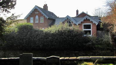
Northfield School
Evidence suggests that as early as 1622 a school was held in St Laurence' Church. However, the origins of the present St Laurence Church of England Schools date from 1714 when the rector, Dr William Worth set up a school for 20 boys who were taught at the west end of the church. Its successor was the Northfield Charity School which was founded c1758 from a legacy left by Dr Worth.
The school was held in the church vestry until 1820 when the school and Sunday school hired a room nearby. By 1832 the school included twelve poor boys who were taught free of charge, and by 1836 there were also six girls on roll.
The church was instrumental in building the new Northfield National School on Church Road in 1845, which absorbed the charity school and catered for up to a hundred children. The school received government grants from 1872 by which time there were two classrooms with the teacher's house standing between. The infant school was enlarged in 1890 and a new girls' school built on a new site eight years later. The old mixed school was then used for boys only. In 1939 the school was reorganised for juniors and infants only and in 1954 renamed St Laurence's Church of England Primary School. By the 1960s the old school buildings were proving inadequate. A new site on Bunbury Road was found by the rector, Fr John Crowle Ellis: the junior school opened there in 1964, and the infant school in 1973.
Northfield Mill on the River Rea at Mill Lane, also known at different times as Digbeth Mill and Cotterills Mill, was still working as a corn mill in 1908 with Walter Morris as
the tenant though the mill was certainly very much older. The buildings gradually fell into ruin during the 1930s and were later demolished. However, part of the waterwheel pit, walls and dry
pool are still visible among bushes and trees alongside the Birmingham and Gloucester railway.
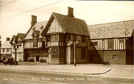
The old village of Northfield lay just off the old Roman road and consequently off the Bromsgrove Turnpike of 1727 which took almost the same route southwards from Bournbrook; this is largely the
modern Bristol Road. The Northfield gate was on the site of Rochester Road; the route is then along the Bristol Road and Lickey Road and over Rose Hill at Lickey.
There was a hamlet at Bell Lane where late 18th-century and early 19th-century cottages still survive. From 1766 a cross-country route was turnpiked from Northfield to Wootton Wawen.
Starting at the Bell Inn on the Bromsgrove Turnpike, the route went via Church Road, Bunbury Road, Middleton Hall Road, Pershore Road South, Redditch Road, Masshouse Lane, Primrose Hill, Icknield Street, Brookhill Road, and then via Weatheroak, Portway, Ullenhall Street to Wootton Wawen on the Stratford Turnpike. The road was disturnpiked after 1809.
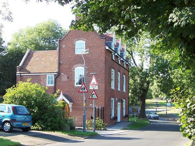
Take a look. Standing back from the Bristol Road South between White Hill Lane and Griffin Close, the Manor House was described as new in 1820; it belonged to the manor of Northfield. However, it had been built around an earlier 18th-century neo-classical-style building. George Cadbury Senior moved here with his wife Elizabeth in 1894 and the Tudor-style stone, brick, timber-framing, projecting porch and carved bay windows dating from that time are probably by George Gadd who designed some of the earliest factory buildings at Bournville. Internally the style is Jacobean with wood panelling, carving and inscriptions.
The house was given to Birmingham University by the Cadbury family after the death of Dame Elizabeth Cadbury in 1953 and was converted by H W Hobbiss in 1958 for use as a hall of residence. Additional wings have since been added to the house which was sold by the university in 2007. The building was seriously damaged by fire in 2014, although plans to restore it and covert it into flats have been put forward.
By 1840 there was some new house building north and west of the original village centre of Northfield; however, east of the village development along the Bristol Road South soon outstripped the
ancient settlement. The focus of the area shifted to the junction of the Bristol Road and Church Road. Growth was further promoted by the opening of Northfield station on the Birmingham &
Gloucester Line in 1869.

Northfield Library opened in 1906, but was almost totally destroyed by fire only eight years later as the result of an arson attack by a group of Suffragettes. The New York Times reported the the previous day's incident in its edition of 13 February 1914.
The Carnegie Library at Northfield, Worcestershire, six miles south of Birmingham, was to-day destroyed by fire set by an "arson squad" of militant Suffragettes. All the books were burned and only the shell of the building was left standing. Papers were found strewn around the place bearing the words: "To start your new library: and "Give women the vote."
The library was rebuilt the same year retaining the original façade. The building was doubled in size in 1984.
Northfield was rapidly built up during the 20th century. In the 1930s large areas of housing were built. Allens Cross estate was built to house over
6000 people on the land of three farms, Allens Cross Farm and Upper and Lower Tinkers farms. In the 1960s housing estates were developed at Ley Hill,
West Heath, Bunbury Road and Vineyard Road. There was also much private infilling and the area was completely urban by 1970.
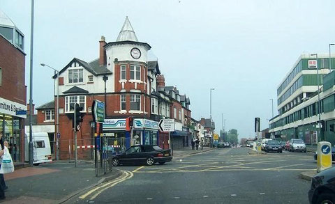
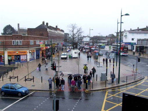
The focus of the area moved from the old village to the junction of Church Road with the Bristol Road, now a thriving shopping centre.
See also Weoley Castle.
William Dargue 07.04.2009/ 15.12.2020
For 19th-century Ordnance Survey maps of Birmingham go to British History Online.
Map below reproduced from Andrew Rowbottom’s website of Old Ordnance Survey maps Popular Edition, Birmingham 1921. Click the map to link to that website.
