

Yardley
formerly in Worcestershire - one of the Domesday manors of Birmingham and an ancient parish
Yardley Fields, Yardley Green
B25 - Grid reference SP134863
Gyrdleahe: first record 972
Yardley is recorded in the Domesday Book as a detached part of Beoley, a Worcestershire manor belonging to Pershore Abbey. The meaning of this Anglo-Saxon placename is unclear. Certainly 'leah' denotes a cleared area of cultivation in a forest area. The first element may refer to a specific area of land. A gyrd or yard was usually reckoned as a quarter of a hide, the latter being the amount of land required to sustain a family and often calculated as 120 acres. Thus a yard of land or yardland was equal to some 30 acres and was perhaps only the area now covered by Old Yardley Park, where, interestingly, part of a medieval ridge and furrow field survives.
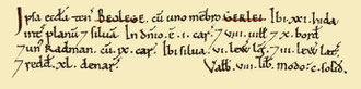
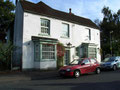
Left: Yardley recorded as Gerlei in the Domesday Book.
Image from the Open Domesday website reusable under a Creative Commons licence.
Yardley was a long thin manor running north to south which measured some 7 miles in length but was only 2½ miles at its widest point. In 1868 the parish was decribed in a national gazetteer:
Yardley, a parish in the upper division of Halfshire hundred, county Worcester, 4½ miles East of Birmingham. It is situated on the Warwickshire border, from which county it is separated by
the river Cole, over which are several bridges connecting this parish with that of Aston. It is traversed by the Warwick and Birmingham canal, and by the Great Western and London and
North-Western railways, the former having a station at the western end of the parish at Acock's Green, and the latter near the eastern boundary at Stechford.
The surface, which is level, is watered by several small streams falling into the Cole. About two-thirds of the land are meadow and pasture, and the remainder chiefly arable, with a little woodland and waste, the greater part of the common having been enclosed. The soil is a stiff loam on a substratum of clay. Great quantities of tiles are made here and conveyed to Birmingham.
Nicholas Esterhazy Stephen Armytage Hamilton's National Gazetteer of Great Britain & Ireland 1868
Being a large parish, it was sub-divided for administrative purposes into four districts known as quarters: the Church End lay north of the Coventry Road, Greet Quarter lay to the south of the
Coventry Road, Broomhall Quarter was between the Warwick and Stratford Roads, and Swanshurst Quarter made up the southern end of the parish.
Yardley remained an agricultural area well into the 20th century, but with increasing urbanisation at the end of the Victorian period the focus of life changed towards the suburban. Although the
rural area was far greater than the urban, the majority of residents were concentrated in such built-up districts as Acocks Green and Sparkhill and they voted in 1911 for amalgamation with the
City of Birmingham. By and large they were voting for a lower council rate and for better services than a rural authority could provide. The modern district of Yardley is now much smaller than
the original extensive manor and is centred the ancient parish church and the old village, now protected within a Conservation Area.
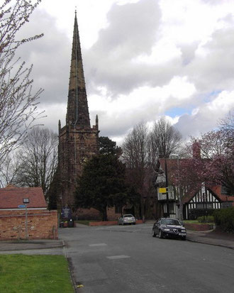
Well worth a visit - Yardley Church
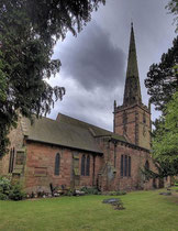
The substantial medieval church of St Edburgha retains much of its early appearance and has Grade I Listed status. Documentary evidence dates a church here to 1165, but the oldest visible part of
the building is the early 13th-century south doorway and the south wall of the chancel. This is poorer quality masonry than the later church and may well be built of local stone; there was an
exposed outcrop of red sandstone at Glebe Farm in the north of the parish.
Perhaps in part because of the deterioration of the stone, much of the church was rebuilt and extended in decorated gothic style sometime after 1300. Later in the 14th century the high chancel arch was built when the chancel itself was extended; the north and south transepts were added at the same time. Such projects have always been expensive and there must have been considerable local wealth and commitment to carry out these undertakings.
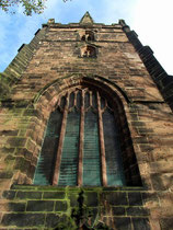
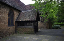
The embattled west tower with its large sandstone blocks and crocketted spire was built by the master mason, Henry Ulm in the 15th century. (Ulm is known to have completed work on Sheldon's tower in 1461.) The carved oak porch is contemporary with the tower, as is the north aisle which was also added at this time.
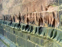
On the plinth of the tower wall about a metre above ground level numbers of vertical grooves may be seen in the sandstone coping stones. It is said that they were made by the
sharpening of arrows. From the time of King Edward IV every township was required by law to set up archery targets which were known as butts. To guard against the threat of a French invasion
archery practice was compulsory on Sundays and on feast days for all men aged between 16 and 60. This statute continued technically in force until the 17th century. While this may be the case,
they may also have been made by people sharpening domestic and agricultural blades. (Similar marks can be seen on the tower at Middleton church.)
Click to enlarge the images below.
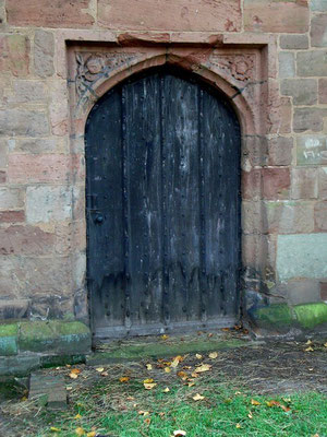
Set in the north wall is a Tudor doorway above which are carved a Tudor rose and a pomegranate. That fruit was the personal symbol of Catherine of Aragon who in 1501 married Henry VII's oldest son, Prince Arthur. After his death she married Henry VIII with well-known consequences for the English Church and the royal succession. Among many other properties, Catherine was granted the manor of Yardley in 1533 as part of the divorce settlement. After the former queen's death in 1536 Yardley reverted to the Crown.
The chancel was lengthened again in 1890, the north-east vestry added and the south transept partly rebuilt. In 1926 a new roof was built supported now by steel girders but with the ancient beams
bolted beneath them. New stone courses were set on the top of the aisle walls with corbels bearing the two oldest spellings of Yardley, as well as royal, diocesan and family arms, the pomegranate
of Catherine of Aragon and the Tudor rose.
Inside the church stands the wooden panelled pulpit of 1627. Contrary to medieval tradition and modern practice, this was installed in front of the altar at a time when the focus of Anglican
services moved towards expounding the word of God and away from the ritual of the mass. By the middle of the 19th century, an appreciation of the orginal medieval arrangement had come back into
vogue.
However, the Birmingham artist, A E Everitt who visited Yardley in 1874 found these 17th- and 18th-century elements 'quaint and picturesque.' In the chancel were the 17th-century altar rail and communion table, heraldic devices and funerary monuments, a flat ceiling and a marble font which, 'although ecclesiastically out of place, yet aid the general effect of the whole.' Clearly his views held no sway, as the chancel was shortly afterwards cleared and the church put back to its traditional arrangement, as it now appears.
In the tower arch is the tomb of Thomas Est and his wife d.1462 and in the chancel a brass memorial of Isabel Wheler who died in 1598. Also in the chancel an elaborate monument of Rev Dr Henry
Greswolde d.1700 shows the priest and his wife at prayer within a curtained cave; medallions of their eleven children frame the recess. A marble vase by Peter Hollins again in the chancel
commemorates Edmund Greswolde d.1863. In the south transept is a relief bust of Edward Est of Hay Hall who died in 1703, while Job Marston of Hall Green d.1701 is commemorated with a black tablet
surrounded by cherubs on the north side of the chancel arch. Set in the west window in 1892 is a stained-glass depiction of the Last Supper by the noted Birmingham firm of Hardman's.
From at least 1552 there were two bells at Yardley; in 1638 Hugh Watts of Leicester hung three bells here, no doubt reusing the existing bell metal. Another bell cast by John Martin of Worcester
was added in 1653 and by 1691 William Bagly had added a fifth. The bells were rehung in 1892 by Henry Bisseker of Birmingham and only ten years later new bearings and a sixth bell were supplied
by the Birmingham bellfounder, James Barwell. In common with many Birmingham bells, all were recast and scientifically tuned by Taylor's of Loughborough in 1950. Two new trebles were added and
the peal hung in a new frame. Yardley is one of Birmingham's premier peals.
The church is surrounded by a graveyard which was certainly in use from the Middle Ages and which was extended to the north in 1833.
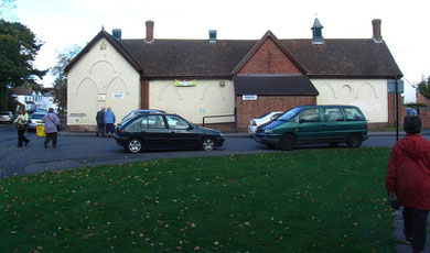
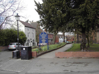
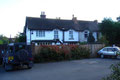
Well worth a visit: Yardley Conservation Area.
Set up to protect the old village with the church at its centre, the Conservation Area encompasses properties in Church Road, Church Terrace, Queens Road, School Lane and was one of the city's
second batch of conservation areas in 1969.
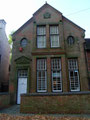
Yardley Old Grammar School
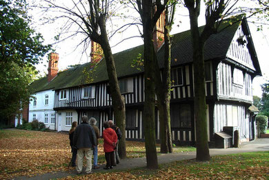
Within the churchyard itself stands Yardley Old Grammar School. Built in the 15th-century as the church house, it was rebuilt in 1512 as a two-storey timber-framed building, and is now Grade II* listed. Its use as a school is first mentioned in a deed of 1575. In 1766 it was recorded that the Yardley Trust were to pay for a schoolmaster who was to be unmarried, given a rent-free house and who would teach the children of Yardley at no cost to their families.
In 1819 there were nearly eighty children attending during the winter months, but the figure was halved in summer when children were needed for farmwork. However, the master began to refuse children who could not read and girls who did not pay their fees. Subsequently the school was run for boys only. By 1846 69 boys were being taught in a single classroom.
The building was enlarged in 1894 and by 1904 there were two schoolrooms and two classrooms, one on each floor. However, the building was condemned by the Board of Education in 1908 and closed the following year when it was replaced by Church Road Council School. Nos. 422-424 to the rear of the school were the schoolmaster's house of late 19th century. Although Yardley churchyard was largely cleared of upright gravestones in 1959, one that still remains in the south-east corner is that of the schoolmaster, James Chell.
The former Sunday school of 1832 stands north of the church at the corner of Church Road and School Lane. This is now the parish hall and is a Grade II Listed building. It took
over the role of the Yardley Vicarage School which had opened in 1828 supported by the vicar and his friends; in 1833 there were 18 boys and 45 girls on roll.
The vicarage itself used to stand on the corner of Church Road and Vicarage Road, but was demolished in 2001. Sheltered housing has now been built here by the Yardley great trust. By 1845 the day school had transferred to the Sunday school building and a teacher's house was built adjoining. While boys attended the Old Grammar School, this school was used for girls and infants. Annual government grants were received from 1872. This school also closed in 1908 and these children also transferred to the new council school on Church Road.
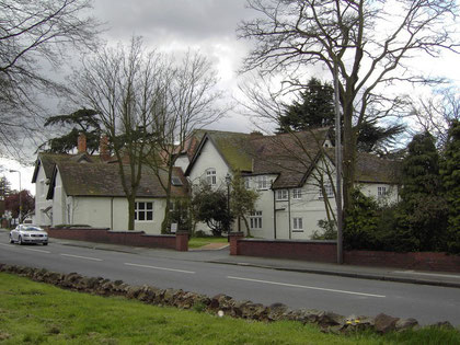
South of the church, on Church Road stands a former Carmelite Monastery, a complex of buildings once secluded behind high walls and now a Grade II Listed building. Although largely mid-19th-century in appearance, it has a 17th-century timber-framed building as its origin. Formerly a private mansion known as The Grange and home of the wealthy Hoskins family, it became a nunnery in 1937 and was converted to its present use as private housing in the 1990s.
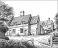
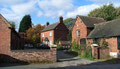
Yardley village was at the heart of a farming community until the early 19th century and the buildings around the church reflect this. No. 451 Church Road, Church Farm is
probably the best complex of surviving farm buildings in urban Birmingham. The farm was built in 1837 on a much older farm site.
Given to the Yardley Charity Trust by local tilemaker Robert Robyns, the present buildings are Victorian: the cowhouse was built c1820 around the timber frame of an earlier building, the barn with its high central doorway dates from 1848 and has evidence of the threshing floor; and the wagon house dates from 1853. The stable was built re-using a pair of medieval crucks, probably from the former farm buildings, and includes a pigeon loft.
The Smithy is still in use as such, though most work is now carried out in a late-20th-century building. All the outbuildings were restored in 1979.
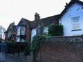
No.433 Church Road, the Cottagers Institute is dated on the gable 1882. It was set up by Ebenezer Hoskins of The Grange to teach gardening and industrial skills to local people. Penny Cottage was built in 1826 by the Yardley Charity Trust for the local blacksmith, John Leake and was restored c1980. Most of the other houses here are early 19th-century: Nos. 437-443, built in 1895, are brick-built houses which replaced six early 19th-century cottages which had in turn replaced an earlier farmhouse.
Behind the 1890s terraced row two more rows are crammed into Church Terrace. At the corner is the tiny former post office. A white-washed dormered cottage, formerly a malthouse,
is originally of Stuart construction, but it is now altered and made into two dwellings. Damson Cottage of Georgian origin, is embedded into the back of the old malthouse.
Yardley Almhouses built beside the Yardley Trust School c1800 were demolished when Old Yardley Park was laid out in 1898 and new almshouses were built in 1904 near School Lane. Also in School Lane is Holly Croft which dates from 1786 and Meriden House dating from c1880. The part of Church Road closest to the church was pedestrianised to very good effect some thirty years ago.
Deriving from Old English gyrd leah, the name of Yardley, which is not unique to Birmingham, is first documented in 972 AD as Gyrdleahe. A leah was 'a clearing' or 'a farm
settlement in a clearing in a woodland area'. Although gyrd may mean a 'stick' or 'twig', it also has the meaning of 'yard' as a measure of area: at one time a yard was defined as a
quarter of an acre. Yardley's name may thus be translated as 'yard clearing', the implication probably being that this was a small clearing. The 10th-century manor was, on the other hand, quite
extensive.
Largely underlain by heavy clay, a soil difficult to work with early ploughs, the original settlement and a number of subsidiary settlements in the manor such as Lea Village, Tenchley and Tyseley, were set up to farm patches of lighter glacial drift. Medieval ridge and furrow is still visible on the parkland behind Yardley church and may represent the site of the original clearing. The clay lands were later worked as the designs of ploughs improved, but cultivation was never easy. If a single horse could plough a field on lighter soil, it took four horses to do the same in Yardley.
Click to enlarge the images in the Yardley Gallery below.
Yardley Gallery


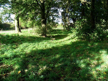
Close to the ridge and furrow behind the church in Old Yardley Park is a is a medieval earthwork known as Rents Moat. Beside the churchyard wall can be seen a tree-covered rectangle, the site of the moated manor house, and on the side furthest from the church a bank can still be seen among the trees.
As the straight northerly line of Church Road doglegs to the west at Barrows Lane, it has been suggested that a straight road originally led directly to this manor house site, which may therefore pre-date the church. If this is the case, the site must have been occupied when the first chapel was built in 1165 during the tenancy of the Beauchamp family of Elmley. However, this was only one of many Beauchamp manors held by the family for some 300 years. The family are thought to have rarely lived here and the hall was very likely sublet.
The de Limesi family were resident during the 13th century, at the time when the present church building was begun. They are the likely sponsors of the work. About 1700 the Allestree family, then
occupants of Rents Moat, moved to Witton Hall, and this hall was subsequently demolished. The silted but still water-filled moat was infilled for safety reasons in 1900 when the Yardley Great
Trust gave land between Church Road and Queens Road for public access as Old Yardley Park.
The Yardley Charter
By the Yardley Charter of AD 972 King Edgar confirmed to Pershore Abbey the ownership of the manor of Yardley. The terms of the charter were set out in Latin, while the
manor bounds were described in Old English with reference to local landmarks. These would have been noted in a perambulation of the manor by representatives of the signatories. It is certain that
this boundary was already old by the time of the charter, and there is reason to think that it may pre-date the Anglo-Saxons.
Yardley was the northernmost manor of Worcestershire which in earlier Anglo-Saxon times had been part of the Kingdom of the Hwicce, itself the successor of the Celtic tribal land of the Dobunii.
This same boundary remained that of Yardley manor and parish well into the 19th century. While references to rivers may often be readily identified, other landmarks are long gone and their
position is conjectured with reference to the known extent of Yardley in later perambulations.
- Aerest of Gyrdlea on Coll;
- 'First from Yard(ley) Field to the (River) Cole.' This refers not to the settlement at Yardley village but to the open field between Church Road and the River Cole. The perambulation may have started where Yardley Green Road crosses the Cole and then followed the river downstream.
- Of Colle on Maer Dic; 'from the Cole to Boundary Dyke.' This dyke may have run from Wychbold Crescent (north end) along Heynesfield Road and served as a boundary between land holdings.
- Of Maer Dic on Blacan Mearcan; 'from Boundary Dyke to Black Border.' Was this near the junction of the Meadway with Lea Hall Road?
- Of Blacan Mearcan on thone Haeth Garan on Dagarding Weg; 'from Black Border to Heath Gore to Dagard's Folks' Way.' The Black Border may refer to 'blacklands', so-named by later settlers who discovered that the soil was blacker than virgin earth. This may have been former agricultural land where fires had burned and manure had been spread. A gore is a triangular piece of ploughland which must have been on the recreation ground south of the Meadway. Dagarding Way is now Broadstone Road/ Pool Way and continues as a footpath in Kents Moat Park. It is one of very few roads named from this early period and presumably led to the settlement of the Dagardings, ie Dagard's people. That village must have been close by, though precisely where is unknown; could it have been at Yardley village itself? The road here marked the boundary between the manors and parishes of Yardley and Sheldon.
- Of Dagarding Weg on Ac Wyllan; 'from Dagarding Way to Oak-tree Spring.' at Welford Avenue.
- Of Ac Wyllan on Bradan Apoldre; 'from Oak-tree Spring to the Broad Apple-tree.' at the junction of Moat Lane and Barrows Lane?
- Of Bradan Apoldre on Maeres Thorn; 'from the Broad Apple-tree to the Thorn on the Baulk.' At the junction of the Coventry Road with Gilbertstone Avenue. A 'baulk' was an earth ridge raised by the plouighs as they turned at the top of the furrow. It marked the boundary between ploughlands. The bush would have been hawthorn or blackthorn, which would have been a notable feature in the great open hedgeless fields before the enclosure movement.
- Of than Thorne on Smalan Broc; from the Thorn-tree to Small Brook. This ran between Measham Grove and Ringswood Road.
- Of Smalan Broc on Cinctunes Broc; 'from Small Brook to Kington Brook.' The boundary ran from Westley Brook at Gilbertstone Avenue where the site of the ford was near the present dip and bend in the road. The boundary then followed Kineton Green Brook across the Robin Hood golf course and ran parallel with Lincoln Road. Here the boundary did not follow the middle of Kineton Green Brook, but was set back by some 300 metres. This probably marked the line between the forest and the marshy land along the stream, suggesting an early claim to this valuable meadow land by the original founders of Kineton Green prior to the coming of the settlers at Yardley.
- Of Cinctunes Broc on Dyrnan Ford; 'from Kington Brook to Hidden Ford.' Through Fox Hollies Park at Gospel Lane. The ford's name suggests that this is a better crossing place in an area of boggy land, but probably known only to locals.
- Of Dyrnan Ford on Brom Halas; 'from Hidden Ford to Broom Hollows.' The boundary followed Gospel Lane to Lakey Lane junction. Broom is a shrub which grows on lighter drier soil. (See Broomhall).
- Of Brom Halas on Hwitan Leahe; from Broom Hollows to White Clearing. Along Redstone Road to Solihull Lane at the southern end of the Robin Hood golf course. This was probably a natural clearing in the forest; but why white?
- Of Whitan Leahe on Leommannincg Weg; 'from White Clearing to Leommann's Folk's Way.' Leommanning Way is now the Stratford Road. It is conjectured that Leomann's Folk lived either at the junction of Stratford Road with the Highfield Road or at Solihull Lane.
- Thonan on Colle; 'then to the River Cole.' South of Slade Lane, then following Shirley Brook east of the Cole and Yardley Wood Brook to the west.
- Of Colle on Meos Mor; 'from the Cole to Moss Marsh.' At Solihull Lodge High Street, the area around Yardley Wood Brook was marshland.
- Of Meos Mor on Ciondan; 'from Moss Marsh to Chinn (Brook),' at Warstock Lane.
- Of Ciondan on Spel Broc; 'from Chinn (Brook) to Spel Brook,' probably Coldbath Brook. Following the course of Haunch Brook parallel to Hollybank Road, Barn Lane to Institute Road/ Billesley Lane junction.
- Thonan on Bullan Wyllan; 'then to Bull's Spring.' From the junction of Billesley Lane and Blenheim Road, then following Billesley Lane to Belle Walk/ Yardley Wood Road/ Stoney Lane. The spring is probably the source of Showell Green Brook, now mostly culverted, which runs alongside Sparkhill Park to the River Cole.
- Of Bullan Wyllan on tha Langan Aec; 'from Bull's Spring to the Tall Oak.' The junction of Stoney Lane and Walford Road.
- Of tha Langan Aec to Mundes Dene; 'from the Tall Oak to Mund's Valley.' From the junction of Walford Road and the Stratford Road following Spark Brook which is now culverted.
- Of Mundes Dene on Colle; 'from Mund's Valley to the Cole.' This is the confluence of Sprk Brook with the River Cole, north of Tyseley Industrial Estate near Seeleys Road at the east end of the Ackers Sports Centre.
- Of Colle eft on Gyrd Leahe; 'from the Cole again to Yardley.'
Archaeological evidence takes the story of Yardley further back and into the Roman period. Although no evidence of a Roman settlement has been found, in 1935 Richard Withers unearthed a hoard of
sixty bronze coins on a building site in Bilton Grange Road. Dating from from AD 330-354 they were probably buried soon after the latter date. While not representing great wealth, they may have
been the savings of a family of moderate means who buried them for safety during a time of social unrest. It will never be known why they were not reclaimed. The hoard is now in Birmingham
Museum.
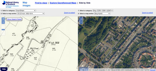
Wash Mill
An important focus of this rural community for over 600 years was the manorial mill. Standing on the River Cole on a site opposite Mintern Road, it was known as Wash Mill, a name which derives from the Old English gewaesc ie. 'ground that gets washed over by water.' Not only the floodplain but the mill itself may have been subject to flooding in winter. It was also called Wodenmill ie. Wood Mill, which probably refers to a significant extent of surviving woodland nearby.
In 1385 Richard Bradewell was the tenant. He it was who restored the timbered mill in return for a lowered rent; the buildings had probably suffered flood damage. A triangular millpool covering over a hectare was fed by a half-mile leat from the River Cole upstream and took in two small streams from Red Hill near the Coventry Road.
By 1525 the mill was again in decay, although its pool was still rented out for its fishing rights. About 1750 Yardley Mill was rebuilt in brick with new farm buildings alongside and it continued to grind corn on its twin wheels until 1914. Both the mill and the farm were demolished in the late 1920s when the area was to be developed for municipal housing. After World War 2 the drained pool was infilled with rubble from city centre bomb sites. The pool site was levelled in 1957 and was subsequently built over with the houses of Kestrel Avenue.
Yardley village remained a small village centre and did not develop into a major focus for a larger area, probably because it lay some way from a major arterial road. Much of the district remained rural until well into the 20th century.
By 1888 building had spread along Church Road towards the Coventry Road and by 1906 there had been some infilling and further building along Stoney Lane to the west of the village. The opening of
railway stations at Stechford in 1844 and at Acocks Green in 1852 helped open up those parts of the manor to development. (See also South Yardley.)
However, the greatest developments at this time were taking place well away from the ancient village. Sparkbrook and Sparkhill were spreading out along the Stratford Road from Birmingham. And it was here, at Court Road, that Yardley Council House was built for Yardley Rural District Council. From less than 3000 inhabitants in 1841, the population of the manor had risen to nearly 60 000 by 1911, at which date a local vote decided to amalgamate with Birmingham in concert with the manors of Aston, Erdington, Handsworth, Kings Norton and Northfield.
The commercial centre of Yardley now lies at the Yew Tree on the Outer Ring Road at Church Road/ Stoney Lane junction. Named after a nearby country
house which stood in Yew Tree Lane, the Yew Tree was a handsome public house built after the First World War but demolished in 2000 to make way for a small shopping centre. Other shops and local
services line the streets around the crossroads here.
Yardley Fields
B25/ B33 - Grid reference SP127865
Church Field and Stichford Field were the medieval strip fields of Yardley. Lying to the west of Yardley village, they stretched down to the River Cole and northwards towards Flaxley Road. After 1847 when the open fields were enclosed, the name continued to be used to describe this location, but it was not subsequently used as a district name for the urban area. (See the Glossary - open fields.)
Ridge and furrow, evidence of the medieval strips is visible on the recreation ground east of Richmond Road. Here may also be seen a clearly defined holloway, part of a field track which sloped down
towards the River Cole and originally continuous with Yardley Fields Road.
Yardley Green
B25 - Grid reference SP124864
The location of the green is not known. Greens were usually common land where local people had the right to gather firewood or graze livestock. Yardley Green Road enters the manor from Bordesley across the River Cole. This crossing at Newbridge was known in the 15th century as Rotyford, meaning 'slippery crossing'. Yardley Green was presumably in the Richmond Road area on the Yardley side of the river.
William Dargue 19.10.08/ 01.08.2010
For 19th-century Ordnance Survey maps of Birmingham go to British History Online.
Map below reproduced from Andrew Rowbottom’s website of Old Ordnance Survey maps Popular Edition, Birmingham 1921. Click the map to link to the website.
