William Dargue A History of BIRMINGHAM Places & Placenames from A to Y
Broomhall
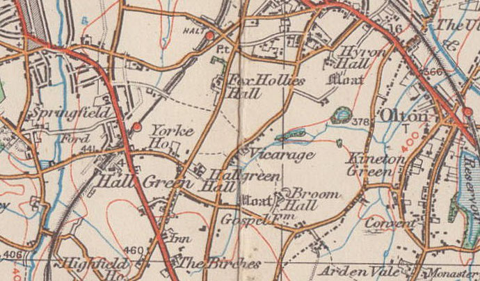
B27 - Grid reference SP118815
Brom halas: first record 972
A Birmingham name that has been in use for over a thousand years, Broomhall is first found documented in the perambulation of the charter of Yardley in 972 AD. A common name across the country
brom halas means 'broom nook' in Anglo-Saxon. The charter reads, Of dyrnan ford on brom halas; from 'the hidden ford to broom nook'. The ford was across Westley Brook,
probably on Gospel Lane by Fox Hollies Park, its name suggesting that this may have been a crossing known only to locals. The perambulation followed Gospel Lane to its junction with Lakey Lane
and Broom Nook.
Although this area lies on the heavy clay lands east of the River Rea, broom is a shrub which thrives on lighter drier soils. (See also Bromford.) This
suggests that there is a patch of lighter glacial drift here whose sandy gravelly soil made for an easier river crossing and was also easier to plough and cultivate. This would explain the
establishment of an early farm on this site. A 'nook' may be understood as a sheltered hollow in the landscape, a good place for a settlement. However, it may also mean a piece of land in the
crook of a river..
Broom Hall was a sub-manor of Yardley with its manor house near the junction of Broom Hall Crescent and Edenbridge Road. The last of the Broomhall family died in the early 15th century and with
him died the family name. Broom Hall was a medieval building within a large oval moated site over half a hectare in area. The timbered hall was rebuilt in brick in Georgian times. As
Broomhall Farm it was occupied as a working farm until 1947 when the last fields were sold for housing. The house was not finally demolished until 1951. A block of flats now
stands on part of the moat, and the footpath from Lakey Lane to Edenbridge Road follows the route of the original driveway. The name is still in use as a streetname.
Broomhall Mill stood on Westley Brook near the west end of Pool Farm Road grinding corn from at least 1609 until c1880, after which all the buildings were demolished. When Fox
Hollies Park was laid out the overflow channels and mill pool were filled in.
As large scale housing developments were being built, in 1932 the City bought some of former fields of Sandpits Farm and Pool Farm to lay out Fox Hollies Park. These had both been owned by
Colonel Walker of Fox Hollies Hall. Westley Brook was landscaped to flow down concrete steps at the bottom of which was the mill site. Although there are
now no visible traces of buildings, a line of trees which bordered the mill pond can still be seen. In contrast to the formality of the original park, a new emphasis on conservation in 1989 has
led to some 3000 trees being planted to enhance the woodland areas.
William Dargue 09.10.2008/ 22.10.2012
For 19th-century Ordnance Survey maps of Birmingham go to British History Online.
Map below reproduced from Andrew Rowbottom’s website of Old Ordnance Survey maps Popular Edition, Birmingham 1921. Click the map to link to that website.