William Dargue A History of BIRMINGHAM Places & Placenames from A to Y
Birchfield/ Birchfield End/ Birchfields
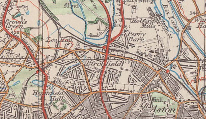
B20 - Grid reference SP069903
Birchsfields: first record before 1850

Fields in the Middle Ages were usually named prosaically after something obvious but significant in order to distinguish them from the other fields: high field, red field, oak field or birch
field, for example. The latter is common across the country.
Birch trees are the first to recolonise cleared land that has been left to nature. While almost nothing is known of agriculture in the Birmingham area during the Roman period, it is known from elsewhere that villas and estates were abandoned as Roman Britain came to an end. It may be that here previously cultivated land had reverted to nature and was later cleared again for use by the Anglian settlers. Birch is a tree that grows readily on sand and pebble land such as underlies much of Handsworth. (See also Bartley Green.)
The open fields of Handsworth manor were enclosed as early as the 13th century, but their precise locations are uncertain. However, it is likely that Birchfield was one of the great fields which were divided into strips and shared among the peasants of the manor.
Birchfield End was one the eight administrative districts of Handsworth in the Middle Ages. It lay along the course of the River Tame. Holford Farm lay in this end.
In 1831 Birchfield Road became part of the New Walsall turnpike, the modern Walsall Road, which was a more direct route than the Old Walsall turnpike of 1727. The new road was
not a new highway as such but laid out as a new through-route using a combination of existing local lanes. From the 18th century the creation of thousands of miles of toll roads across the
country revolutionised travel. At the peak in 1841 there were twenty-eight coaches coming into Birmingham every day from every direction. However, this was not to last.
In 1837 Birmingham's first railway was built, the Grand Junction line to Liverpool. The opening of Perry Barr Station the following year marked the beginning of the end for the stage coach route. Horse power could not compete against the speed of rail travel which was some four times faster. Nor could coaches or carts match the number of passengers or goods carried by a train. Takings at the toll bars on the Birchfield Road declined progressively and tolls were finally abolished in 1879.

The road is now a main artery into the City Centre with up to four lanes in each direction. It was one of the first in Birmingham to be developed with underpasses and flyovers designed to ease traffic flow by separating local and through traffic. The underpasses at Aston Lane junction and Six Ways and the flyover at Trinity Road were all in use by 1963.
The flyover is currently (2020) being removed for a new single-level junction.
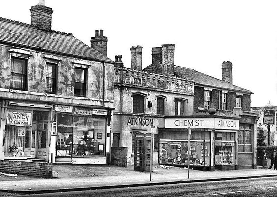
Below left: Birchfield Road near the junction with Heathfield Road.
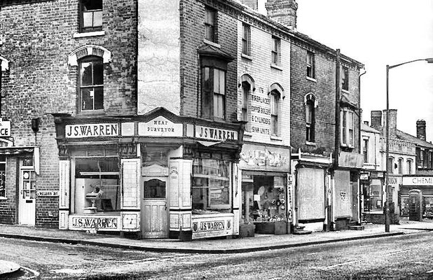
Below centre: Birchfield Road approximately opposite the junction with Arden Road. All of these shops were cleared to make room for the road to be widened and for the flyover.
Photographs and text reproduced with the kind permission of the late Keith Berry.
Below right: Birchfield Road junction with Aston Lane - photographed posted by Leonard Price on Birmingham History Facebook group


Take a look at Holy Trinity Church.
This area was developed for housing from the 1850s and given a focus in 1864 with the opening of Holy Trinity Church at the corner of Birchfield Road and Trinity Road. This church was part of the nationwide boom in urban church-building and the revival of gothic church architecture. In the first half of the 19th century a new church was built in Birmingham on average every two and a half years; in the second half-century this increased to one every year. Almost all were designed in the revived gothic style of the Middle Ages and Holy Trinity was no exception.
Designed in rock-faced sandstone by the noted Birmingham architect, Julius Alfred Chatwin, it is a good interpretation of 12th-century Early English style. The church was built in 1864 as a daughter church of Handsworth; it was emparished the following year. The church has a spired south-west tower which may originally have held a bell. A set of eight tubular bells hung in 1897 for Queen Victoria's Diamond Jubilee are chimed from a plucking manual on the first floor of the tower. The chimes were almost certainly made Harrington, Latham & Co in Coventry.

The Jame Masjid Sunni mosque standing opposite Holy Trinity is a spacious red-brick building with a golden dome and stained-glass windows. It was built in 1988 with £2 million given by President Saddam Hussein of Iraq and originally named after him.
After the Gulf Wars of 1991 and 2003 the name of the mosque was changed to the less contentious Jame Masjid ie. Main Mosque. The mosque is indicative of the influx of people of Pakistani origin into Birmingham in the second half of the 20th century and is one of some 80 mosques in the city.
Housing development here continued apace during the second half of the 19th century. Although open land remained west of Birchfield Road into the 20th century, most of the area was built up by 1900. But from as early as 1838 when Perry Barr Station was opened, the focus of the area began to change. With the development in the mid-20th-century of the shopping centre on Birchfield Road at Aston Lane junction, the name Birchfield has rather fallen out of use.
Added to this was the massive reconstruction of the Birchfield road system into an eight-lane highway with underpasses and flyovers, which necessitated the demolition of many houses and, perhaps more significantly, shopping centres such as that at Witton Road. However, the concept of Birchfield Road and its immediate surroundings as a locality still has currency. The flyover here, which was opened in 1970, is to be demolished and a single-level junction created in 2021.
One of the country's most famous athletics clubs takes its name from the district. Birchfield Harriers, along with Aston Villa Football Club and Warwickshire County Cricket Club had their early
meetings at Aston Lower Grounds near Aston Hall. The club was founded by a group of local enthusiasts in 1877 with the first track meeting at the Aston Lower Grounds in 1879. The club moved to
its own stadium at Perry Barr, now a greyhound track, and to the Alexander Stadium in 1976, a stadium to be redeveloped for the 2022 Commonwealth Games. The Harriers was the
first such club in the country to own its own track and to employ a full-time administrator.

Right: Holy Trinity Church
Thanks for the use of this postcard to JKC on the Birmingham History Webring Forum. See also John Houghton & Rod Birch's website Astonbrook through Aston Manor.
William Dargue 22.03.2009/ 05.11.2020
For 19th-century Ordnance Survey maps of Birmingham go to British History Online.
Map below reproduced from Andrew Rowbottom’s website of Old Ordnance Survey maps Popular Edition, Birmingham 1921. See Acknowledgements. Click the map to link to that website.