

William Dargue A History of BIRMINGHAM Places & Placenames from A to Y
Bordesley Green
B9 - Grid reference SP095864
la Grene de Bordeslei: first record 1285
The green was Bordesley's demesne pasture, not in this case, common grazing but land which belonged to the lord of the manor.
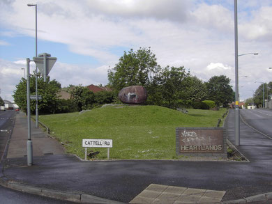
The green was probably around the junction of Cattell Road and Garrison Lane where Ondre Nowakowski's statue of The Sleeping Iron Giant 1992 is one of a number of public art works commissioned by the Heartlands Development Corporation. It is a large head in cast-iron lying on its side. Being close to St Andrew's, home of Birmingham City Football Club, the fans, the 'blue noses' regularly paint the giant's nose blue.
As so often happens with urban development, the name of Bordesley's green was subsequently adopted for a wider area of building developments along and around the road of the same name from the end of the 19th century. The district is typified by long rows of working-class terraces in streets some of whose names, Pretoria and Botha Roads for example, bear witness to the Boer War 1899-1902.

19th-century housing development
By 1834 there was scattered ribbon development from Bordesley along Bordesley Green from the junction of Cattell Road and Garrison Lane as far east as Blake Lane.
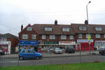
By 1888 the area was completely built up from Birmingham between Bordesley Green and the Coventry Road as far as Charles Road; to the east of that remained countryside. A shopping centre grew up around the junction of Bordesley Green and Bordesley Green Road.
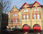
By 1906 urban development had spread eastwards as far as Blakeland Street and Mansell Road and included a fire station and police station, both of which buildings survive, though neither
serve their original purpose.
Many late-Victorian and Edwardian houses remain in Bordesley Green and much of the area has physically changed changed little since then.

The 20th century
Council houses were built between 1924 and 1927 on the Batchelors Farm estate which lies between Belchers Lane and the River Rea. A wide stretch of land along the river here continued the open green space along the Rea Valley created by Yardley Council in 1909.
The road named Bordesley Green was extended as a dual carriageway to Stechford as Bordesley Green East, and because of the road name, this area is now understood as part of Bordesley Green.
Bordesley Green East is the home of Heartlands Hospital. It started life as an isolation hospital built in 1895 on the fields of Howlets Farm, at that time at the city's extreme eastern limit and
several miles from the urban area. It later became East Birmingham Hospital, and c1992 Heartlands Hospital.
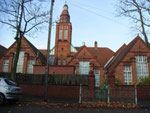
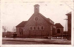
At Drummond Road/ Marchmont Road Bordesley Green Board School was opened in 1902 by the Birmingham School Board with accommodation for over a thousand children. The school was
reorganised for senior girls, juniors and infants in 1931. During World War 2 the junior and infant departments were closed and the buildings were used by the Civil Defence. The separation of
senior boys and girls, juniors and infants happened in many schools during the late 1920s and 1930s. However, this school is one of few remaining still share the same site.
The allotments off Broadway Avenue were set out as part of the Batchelors Farm estate in the 1920s. In 1976 an amateur gardener unearthed part of an early Bronze Age flint dagger here, an
artefact some 4000 years old. However, new topsoil had been brought onto the site four years earlier, so the origin of the find is uncertain. There is, however, no reason that this should not be
of Birmingham origin - similar finds have been made elsewhere in the city.
See also Bordesley and The Ideal Village.
Click to enlarge the images in the Bordesley Green Gallery below.
William Dargue 18.09.2008/ 09.11.2020


For 19th-century Ordnance Survey maps of Birmingham go to British History Online.
Map below reproduced from Andrew Rowbottom’s website of Old Ordnance Survey maps Popular Edition, Birmingham 1921. See Acknowledgements. Click the map to link to that website.
