

William Dargue A History of BIRMINGHAM Places & Placenames from A to Y
The Froggery/ The Froggary
B5 - Grid reference SP068867
Froggary: first record 1731
The street so-named and its immediate district are now under the site of New Street Station. The development of the low-lying area between New Street and Edgbaston Street dates from the medieval expansion of the town. Its name very likely derives from the fact that it was watery and ill-drained; it is a name found elsewhere in England. By the 18th century the Froggery had become a slum area and by the 19th century its squalor was notorious. Part of the district was known as The Rookeries, an ornithological term used colloquially in the 19th century as a by-word for dilapidated tenements, the haunts of thieves and crooks. See also The Hinkleys.

Grand Central Station
In 1852 the district was razed to the ground when the London & North-Western Railway began the construction of New Street Station for trains to Liverpool and London. This site in the town centre was specifically chosen because it was low-lying and more on a level with the lines which approached from below the Birmingham plateau.
Nonetheless tunnels had to be dug to take the line under the Birmingham ridge at Moor Street and a viaduct built from the old terminus at Curzon Street which lay in the valley of the Rea. Known then as Grand Central Station, this building had the biggest roof-span in the world at the time, and was a symbol of the booming Victorian city.
In the mid-1960s the station (New Street) was completely rebuilt with an innovative indoor shopping centre above twelve below-ground platforms to cater for over 600 trains and some 60,000 passengers a day.
Between 2010 and 2015 the station was rebuilt yet again with a new concourse three-and-a-half times larger than the previous one, with a domed atrium with shopping and restaurants on the floor above known as Grand Central, refurbished platforms, a new station facade and new entrances.

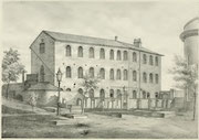
The Old Meeting
The Presbyterians, later Unitarians, first worshipped in a small room somewhere in Digbeth which was licensed after the 1672 Declaration of Indulgence allowed non-conformists to build places of
worship. Under James II worship had to be held in secret, but with the passing of the Act of Toleration in 1689 the (Old) Meeting (House) was built in Phillip Street. This lay off Dudwall Lane,
later known as Pinfold Street, a site now under New Street Station.
The Meeting was burnt down in high-church riots in 1715 and wrecked again in the Priestley Riots of 1791. It was again rebuilt in 1794 with schoolrooms and a library attached.
The burial ground was used from 1696, enlarged in 1779, 1869 and 1870; it was closed for burials in 1873 for all but reopened family graves.
The building was demolished 1882 for the enlargement of New Street Station and the remains of the dead belonging to both the Old and New Meetings were reinterred at Witton Cemetery where an obelisk marks the site. A new chapel in gothic style was built on Bristol Street in 1885. The chapel was destroyed by German bombs in 1940, but services continued to be held in the attached school until 1949.
The illustrations above and below are taken from Catherine Hutton Beale 1882 Memorials of the Old Meeting House and Burial Ground Birmingham, a book written immediately prior to its demolition.


William Dargue 21.07.2012/ 18.11.2020