

William Dargue A History of BIRMINGHAM Places & Placenames from A to Y
Glebe Farm
B33 - Grid reference SP141878
The word glebe derives from Latin, glaeba, meaning soil, earth or land. In the later Middle Ages it took on the specialist meaning of land owned by and farmed or rented out by the parish priest; this may have consisted of strips in the open fields or, after enclosure, may have been consolidated as a farm. Glebe Farm is so-named because it was once the property of the priest of Yardley.
During the Middle Ages an outcrop of red sandstone was visible at Glebe Farm, unusual in an area which lies predominantly on heavy clay. The sandstone at the north end of the Yardley ridge is known to have been quarried in the early 13th century to build a new south doorway and the south chancel wall of Yardley church. From here, the northernmost point of Yardley, a straight route, Church Road led to the parish church.
Until the 19th century this area was known as The Riddings, a medieval name indicating that the land had been cleared of trees for agriculture.
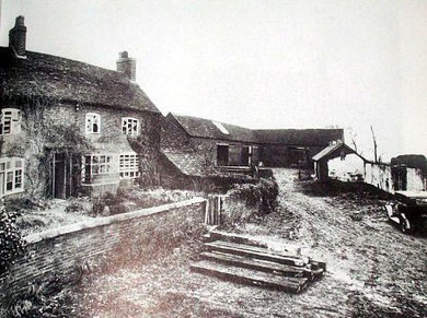
A tenant farmer lived in the moated timber-framed house here which dated from c1300.
Even in the 19th century, maps still bore evidence of that moated site by the fieldnames, Moat Leasow and Fish Pool Piece, which contained the north and the east arms of the moat. The farmhouse stood near the junction of Glebe Farm Road and Croxton Grove and was known as Walters Farm from the Middle Ages; William Walters is recorded here in 1381. The family gradually built up land holdings in this area, but by 1464 had disappeared without trace. The farm was bought by Matthew Boulton in the late 18th century, later coming into the hands of the rector of Yardley whence its subsequent name, for glebe was land owned by the priest.
The 1847 tithe map of Yardley lists Robert Hargrave as the tenant farmer of Glebe Farm and some 140 acres, which were then owned as rector by Rev Henry Gwyther. That farmhouse was abandoned in
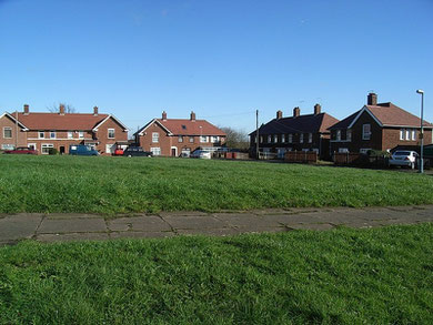
the late-Georgian period when Glebe Farm House was built. The latter in its turn was demolished in 1934 in preparation for the laying out of the council estate. Its name lives on now as a
district name which it came into use after the Second World War as municipal housing development in the area was completed.
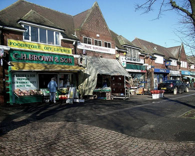
A local shopping centre was built around a short length of a short tree-lined dual carriageway at the junction of Glebe Farm Road and Kitts Green Road, with a branch library, community centre and a public house. The library was a concrete prefabricated building opened in 1952 by the Lord Mayor of Birmingham, Alderman Ralph Yates. Praising the light and airy new building he declared,
We are inclined to look on a library as something dingy, because we are used to our Central Library, which is hardly a thing of beauty or a joy for ever.
He was referring to the old, now lamented, Victorian building in town which was demolished in the late 1960s.
The public house known as The Glebe was demolished and replaced with housing c2000.
With the nearest school at Stechford, Audley Road Council School was opened in temporary buildings in 1933 for some 200 juniors and infants. The permanent block for over 400 children opened the following year and a permanent block for senior children opened the year after that.
As the number of children on the estate continued to increase, the old temporary huts were used by the infant school with extra accommodation being taken at Glebe Farm community centre. The
senior school closed in 1941 and the buildings were taken over by the Civil Defence during World War 2 and the children went to Lea Village Council School. During the war both junior and senior
departments were damaged by German bombs. In 1954 the schools were renamed Audley County Primary School and Audley County Modern School. The latter was the senior or secondary school for boys and
girls and closed in 1963.
The German planes, whose bombs were dropped on Audley School, were presumably en route to destroy the James Booth aluminium factory which had been built nearby on Kitts Green Road in 1938. Parts
were made here for building Spitfire fighter planes (See Castle Vale). The plant has passed through a number of hands since then supplying high-strength
aluminium plate to aircraft builders throughout the world including Airbus and Boeing.
See also Kitts Green.
William Dargue 05.03.2009/ 14.07.2012
For 19th-century Ordnance Survey maps of Birmingham go to British History Online.
Map below reproduced from Andrew Rowbottom’s website of Old Ordnance Survey maps Popular Edition, Birmingham 1921. Click the map to link to that website.
